Staff Web Directory

registrar@umat.edu.gh

+233 3123 20324/20280


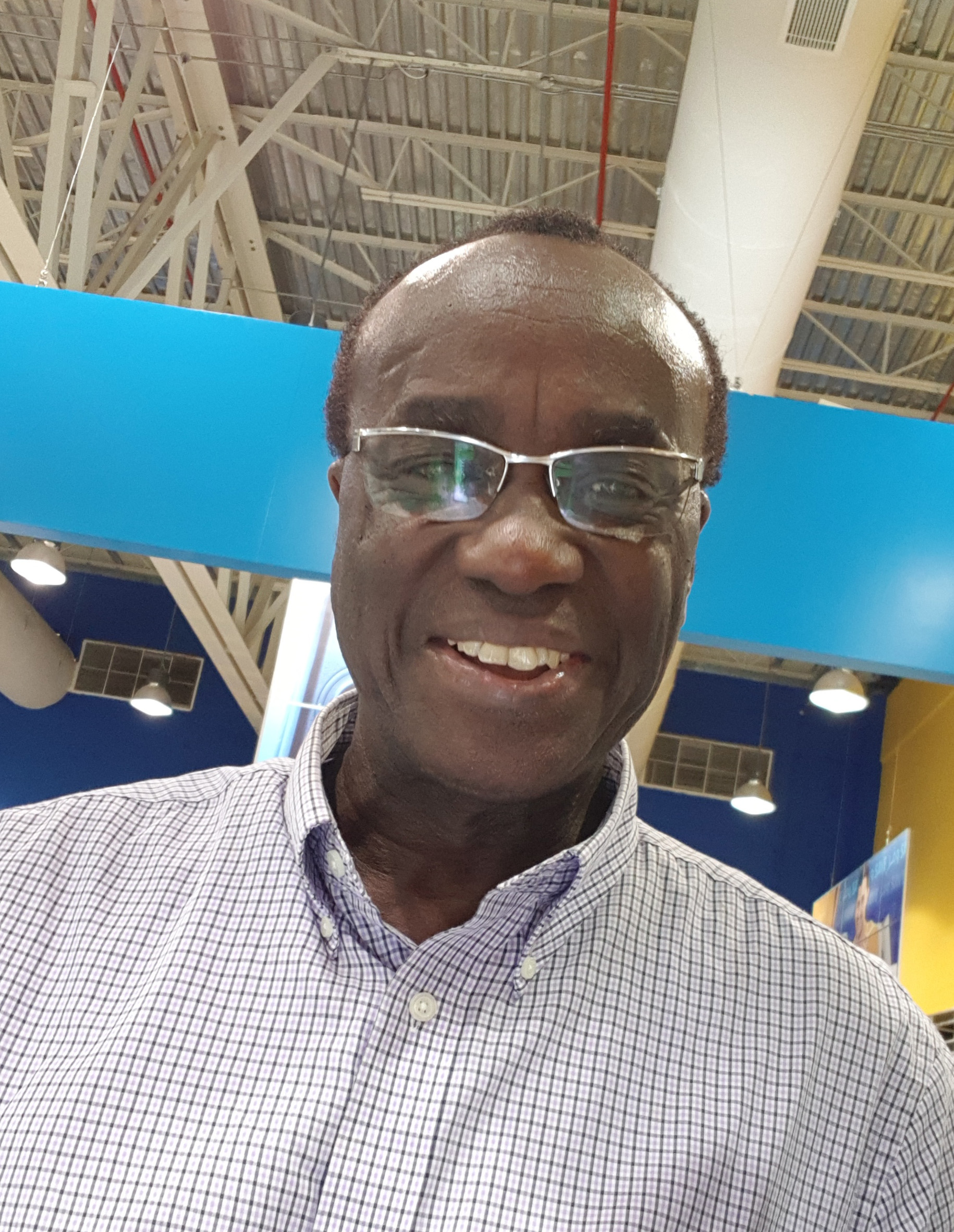
Prof. Andy Yaw Kwarteng

akwarteng@umat.edu.gh


Position

Adjunct Professor

Department

Geological Engineering

Research Interest

Optical and radar remote sensing data processing and applications to desert, urban, coastal and marine environments, GIS, mineral exploration and geology, satellite meteorology, environmental assessment, climate change and migration of birds.


Prof. Andy Yaw Kwarteng has over 40 years of  industrial and academic experience in mineral exploration and optical and radar remote sensing data processing and applications  He has professional working experience in Ghana, Canada, USA, Saudi Arabia, Kuwait, UAE, and Oman. He has participated in over 30 research and consultancy projects related to remote sensing applications to diverse environments, and environmental monitoring. He has several years of experience in teaching introductory and advanced courses in remote sensing and GIS at undergraduate and graduate levels, in addition to the supervision of MS and PhD. theses. He has organized several short courses in these areas and other environmental related areas. His specific professional experience includes:

  • Remote sensing applications to urban, marine, coastal, desert and forest environments
  • Digital image processing
  • Geographic information systems
  • Environmental monitoring
  • Climate change
  • Vegetation monitoring
  • Satellite meteorology
  • Rainfall analysis
  • Migration of birds
  • Mineral exploration
  • Geology
1988
Ph.D.
University of Texas at El Paso (Remote Sensing and Economic Geology)
1984
M.Sc.
McGill University (Mineral Exploration)
1978
B.Sc.
University of Ghana (Geology and Physics)
1984--1988
University of Texas at El Paso, USA
1982--1984
McGill University, Montreal Canada
1975--1978
University of Ghana, Legon Accra
2008--2019
Coastal Education and Research Foundation (CERF)
2002--2019
Geological Society of Oman (GSO)
1995--2016
2.IEEE International Geoscience and Remote Sensing Society (IGARSS)
1995--2019
Asian Conference for Remote Sensing (ACRS)
1986--2019
1.American Society of Photogrammetric Engineering and Remote Sensing (ASPRS)
1996
Application Development and Research Opportunity (ADRO) (Radarsat beam Modes for Characterizing Desertification and Coastal Processes in Kuwait (Project ID: 686) by the Canadian Space Agency
1987
American Institute of Mining, Metallurgical and Petroleum Engineering Scholarship
1987
Bruce Davidson Memorial Award (outstanding doctoral student)
1984
International Atomic Energy Agency (IAEA) Fellowship
1983
David Harrigan Award (outstanding mineral exploration student)
1982
Ghana Government Scholarship
1975
Ghana Geological Survey Scholarship
  1. Bom, R.A., Conklin, J.R., Verkuil, Y.I., Alves, J.A., De Fouw, J., Dekinga, A., Hassell, C.J., Klaassen, R.H.G., Kwarteng, A.Y.,Rakhimberdiev. E., Rocha, A.,Ten Horn, J., Tibbitt, L, Tomkovich, P.S., Victor, R., Piersma, T. (2022), "Central‐West Siberian‐breeding Bar‐tailed Godwits (Limosa lapponica) segregate in two morphologically distinct flyway populations", Ibis, 64 2, 468-485.

  2. Bom, R. A., van Gils, J.A., Molenaar, K., Kwarteng, A.Y., Victor, R., and Folmer, E.O. (2021), "Correction to: The intertidal mudflats of Barr Al Hikman, Sultanate of Oman, as feeding, reproduction and nursery grounds for brachyuran crabs.", Hydrobiologia, 848 , 751-752.

  3. Bom, R. A., van Gils, J.A., Molenaar, K., Kwarteng, A.Y., Victor, R., and Folmer, E.O. (2020), "The intertidal mudflats of Barr Al Hikman, Sultanate of Oman, as feeding, reproduction and nursery grounds for brachyuran crabs.", Hydrobiologia, 847 20, 1-15.

  4. Sousa, D., Small, C., Spalton, A. and Kwarteng, A. (2019), "Coupled spatiotemporal characterization of monsoon cover and vegetation phenology.", Remote Sensing, 11 1203, 1-22.

  5. Sundararajan, N., El-Hussain, I., Mohamed, A.M.E., Deif, A, El-Hady, S., Al-Jabri, K., Al-Rawas, G, El Zain, Y., Kwarteng, A., Al-Wardi, M. (2019), "Shear wave velocity characteristics in parts of Muscat, Sultanate of Oman- A measure of earthquake hazard assessment.", Journal Geological Society of India, 93 , 515-522.

  6. McGrady, M.J., Al Fazari, W., Al Jahdhami, M., Fisher, M., Kwarteng, A.Y., Walter, H. and Oli, M.K. (2019), "Island accessibility and distance to beach influence nesting success of Sooty Falcons Falco concolor in Oman.", Ibis, 161 , 162-171.

  7. Esch, T., Asamer, H., Bachofer, F., Balhar, J., Boettcher, M., Boissier, E., d' Angelo, P., Gevaert, C.M., Hirner, A., Jupova, K., Kurz, F., Kwarteng, A.Y., Mathot, E., Marconcini, M., Marin, A., Metz-Marconcini, A., Pacini, F., Paganini, M., Permana, H., Soukup, T., Uereyen, S., Small, C., Svaton, V., and Zeidler, J.N. (2018), "Digital world meets urban planet – new prospects for evidence-based urban studies arising from joint exploitation of big earth data, information technology and shared knowledge.", International Journal of Digital Earth, 13 , 136-157.

  8. Amoatey, P., Sulaiman, H., Kwarteng, A., and Al-Reasi. (2018), "Above-ground carbon dynamics in different arid urban green spaces published.", Environmental Earth Sciences, 77 431, 1-10.

  9. Bom, R.A., van Gils, J.A., Oosterbeek, K., Deuzeman, S., de Fouw, J., Kwarteng, A.Y., Kentie, R. (2018), "Demography of a stable population of Crab Plovers wintering in Oman.", Journal of Ornithology, 159 , 517-525.

  10. Gunawardhana, L.N., Al-Rawas, G.A., Kwarteng, A.Y., Al-Wardy, M., and Charabi, Y. (2018), "Potential changes in the number of wet days and its effect on future intense and annual precipitation in northern Oman.", Hydrology Research, 49.1 , 237-250.

  11. Kwarteng, A.Y., Al-Hatrushi, S.M., Illenberger, W.K. McLachlan, A. (2016), "Grain size and mineralogy of Al Batinah beach sediments, Sultanate of Oman. ", Arab Journal of Geosciences, 9(9) 557, 1-18.

  12. Kwarteng, A.Y., Al Hatrushi, S.M, Illenberger, W.K., McLachlan, A., Sana, A. Al Buloshi, A., and Hamid, K.H. (2016), "Beach erosion along Al Batinah coast, Sultanate of Oman.", Arab Journal of Geosciences, 9(2) 85, 1-20.

  13. Mettraux, M., P.W. Homewood, A. Y. Kwarteng, and J. Mattner. (2011), "Coastal and continental sabkhas of Barr Al Hikman, Sultanate of Oman.", International Association of Sedimentology. Spec. Publ, 43 , 183-204.

  14. Eason, P., R. Victor, J. Eriksen, and A. Kwarteng. (2009), "Status of the exotic Ring-necked Parakeet, Psittacula krameri, in Oman.", Zoology in the Middle East, 47 , 29-38.

  15. Kwarteng A.Y., A.S.S. Dorvlo. and G.T. Vijaya Kumar. (2009), "Analysis of a 27- year rainfall data (1977-2003) in the Sultanate of Oman.", International Journal of Climatology, 29 , 605-617.

  16. Kwarteng, A.Y. C.M. Dobson, J. Kellndorfer, and R. Williams. (2008), "SAR-based land-cover classification of Kuwait.", International Journal of Remote Sensing, 29 23, 6739-6778.

  17. Homewood, P., V. Vahrenkamp, M. Mettraux, J. Mattner, B. Vlaswinkel, H. Droste and A. Kwarteng (2007), "Bar Al Hikman: a modern carbonate and outcrop analog in Oman for Middle East Cretaceous fields.", First Break, 25 , 55-61.

  18. Kwarteng, A.Y. and A. Al-Enezi. (2004), "Assessment of Kuwait’s Al-Qurain landfill using remotely sensed data.", Journal of Environmental Science and Health, Part A—Toxic/Hazardous Substances & Environmental Engineering, 39 2, 351-364.

  19. Kwarteng, A. (2001), "Landsat Thematic Mapper assessment of oil lakes and oil-contaminated soils in the Burgan oil field, Kuwait.", Contaminated Soil, Sediment and Water, 2001 10, 52-62.

  20. Omar, S.A.S, R. Misak, H. Minkarah, P. King, A. Kwarteng, H. Abo-Rizq and W. Roy. (2001), "Land-use mapping for the State of Kuwait using the geographical information system (GIS).", Arabian Gulf Journal of Scientific Research, 19 2, 59-65.

  21. Kwarteng, A.Y., Viswanathan M.N., M.N. Al-Senafy, M.N., and Rashid, T. (2000), "Formation of fresh groundwater lenses in northern Kuwait.", Journal of Arid Environments, 46 2, 137-155.

  22. Kwarteng, A.Y., V. Singhroy, R. Saint-Jean, and D. Al-Ajmi (1999), "The usefulness of different RADARSAT SAR beam modes in the assessment of oil lakes and polluted surfaces in the Greater Burgan oil field, Kuwait.", Canadian Journal of Remote Sensing, 25 3, 291-301.

  23. Kwarteng, A.Y. (1999), "Remote sensing assessment of oil lakes and oil-polluted surfaces at the Greater Burgan oil field, Kuwait", International Journal of Applied Earth Observation and Geoinformation, 1 1, 36-47.

  24. Kwarteng, A.Y. and P.S. Chavez, Jr. (1998), "Change detection study of Kuwait City and environs using multitemporal Landsat Thematic Mapper data.", International Journal of Remote Sensing, 19 9, 1651-1662.

  25. Kwarteng, A.Y. (1998), "Multitemporal remote sensing data analysis of Kuwait’s oil lakes.", Environment International, 24 1/2, 121-`37.

  26. Kwarteng, A.Y., and D. Al-Ajmi (1996), "Using Landsat Thematic Mapper data to detect and map vegetation changes in Kuwait.", International Archives of Photogrammetry and Remote Sensing, 31 B7, 398-405

  27. Kwarteng, A.Y., and T. A. Bader (1993), "Using satellite data to monitor the 1991 Kuwait oil fires.", Arabian Journal of Science and Engineering, 18 , 95-115.

  28. Kwarteng, A.Y., and P.S. Chavez, Jr. (1990), "Digital image processing of airborne geophysical data for uranium-mineralized breccia pipes exploration in northwestern Arizona. ", Geophysics, 55 , 965-976.

  29. Chavez, Jr., P.S., and A.Y. Kwarteng (1989), "Extracting spectral contrast in Landsat Thematic Mapper image data using selective principal component analysis", Photogrammetric Engineering and Remote Sensing, 55 , 339-348.

  30. Pingitore, Jr., N.E., Y. Rangel, and A. Kwarteng (1989), "Barium variation in Acropora palmata and Montastrea annularis", Coral Reefs, 8 , 31-36.

  1. Kwarteng, A.Y. (2023), "ANNUAL CONFERENCE of the GHANA INSTITUTE OF GEOSCIENTISTS (GHIGCON–2023) Harnessing the Hydrocarbon and Mineral Resource Potential of Sedimentary Basins in Ghana UNIVERSITY OF GHANA, LEGON-ACCRA, G", REMOTE SENSING OF THE MODERN CARBONATE SYSTEM OF BARR AL HIKMAN PENINSULA, OMAN., 15-16
  2. McGrady, M.J., Meyburg, B. –U., Kwarteng, A. Y. and Touqi, S.M. (2018), "Rapture Research Foundation Annual Meeting Nov 12-16, 2018, Skukuza Camp, Kruger National Park, South Africa", Assessing risk and prioritizing remedial work to reduce electrocution of Egyptian vultures (Neophron percnopterus) in Oman.,
  3. Chitrakar, P., Sana, A, Baawain, M., Al-Mamun, A., Bruss, G., and Kwarteng, A. (2018), "13th International Conference on Coasts, Ports and Marine Structures 26-28 November 2018, Tehran Iran.", Preliminary assessment of water quality in the coast of Muscat, Oman.,
  4. Bruss, G., Kwarteng, A. Baawain, M, Sana, A., Chitrakar, P., Al-Abdali1, F. and Al-Habsi1, H. (2018), "13th International Conference on Coasts, Ports and Marine Structures 26-28 November 2018, Tehran Iran.", Coastal currents on the northern Omani shelf.,
  5. Small, C.; Elvidge, C, Kwarteng, A., Li, X., Soydan, H. (2018), "Mapping Urban Areas from Space (MUAS 2018), Oct 30-31, Frascati, Rome, Italy.", Spatiotemporal Analysis of Seasonal and Interannual Night Light Dynamics of Southwest Asia: 1992 to 2017.,
  6. Kwarteng, A.Y. and Mozumder, C. (2016), "Proceedings, 37th Asian Conference on Remote Sensing (ACRS2016); Oct 17-21, Colombo Sri Lanka", Monitoring chlorophyll-a and sea surface temperature variations in SE Arabian Gulf and NW Sea of Oman from MODIS Aqua data.,
  7. Piersma, T., Bom, R., Chan, Y., ten Horn, J., Hassell, C., Dekinga, A., Klaassen, R. H.G., A. Kwarteng, A. and Tibbitts, T.L. (2016), "WSG Conference Ireland, September 2016.", Tracking the northward migration of Bar-tailed Godwits worldwide in 2016.,
  8. Bom, R.A., Kwarteng, A.Y. and Jan A. van Gils, J.A. (2016), "4th International Conference of Oceanography and Marine Biology, Jul 18-19, Brisbane, Australia.", Barr Al Hikman as an important nursery ground for blue swimming crabs Portunus segnis.,
  9. Van Gils, J.A., Bom, R.A., Fijen, T. and Kwarteng, A.Y. (2015), "5th International Conference on Estuaries and Coasts (ICEC2015), Nov 2-4. Muscat, Oman", Cascading predator-prey effects in a pristine seagrass-based food web., 46
  10. Kwarteng, A.Y., Bom, R.A. and van Gils, J.A. (2015), "5th International Conference on Estuaries and Coasts (ICEC2015), Nov 2-4. Muscat, Oman", Crab Plover Dromas ardeola movement and migration at Barr Al Hikman, Sultanate Oman. , 190-198.
  11. Kwarteng, A.Y., Bom, R.A. and van Gils, J.A. (2015), " Joint meeting of the American Ornithologists’ Union and Cooper Ornithological Society, Norman Oklahoma, Jul 28-Aug 2", Migration and local movements of Crab Plover Dromas ardeola wintering in Barr Al Hikman, Sultanate Oman., 37
  12. El-Hussain, I., A. Deif, K. Al-Jabri, G. Al-Rawas, Y. El Zain, A. Kwarteng, M. Al-Wardi and N. Sundararanjan (2013), "National Conference on Earth Sciences in India: Challenges and Emerging Trends (ESICET-2013), November 7-9, 2013 Roorkee, India", Shear Wave Velocity by MASW in Earthquake Hazard Assessment Studies in and Around Muscat, Oman.,
  13. Kwarteng, A.Y. (2013), "Symposium on Muscat History and Civilization, Muscat, November 2-3, 2013.", Urban Growth of Muscat: Observations and Analysis from Multitemporal Satellite Imagery.,
  14. Kwarteng, A.Y., Al-Hatrushi, S.M., Illenberger, W.K. (2012), "International Conference on the Geology of the Arabian Plate and the Oman Mountains, Jan 7-9, 2012, Muscat, Oman,", Beach sediment mineralogy and grain size characteristics along Al Batinah coast, Oman., 126
  15. Kwarteng, A.Y. (2011), "32nd Asian Conference for Remote Sensing (ACRS), Oct 3-7, Taipei, Taiwan", SAR Imagery Analysis of Vegetation in Arid Environment., 6 pp.
  16. Kwarteng, A.Y., and Al-Rawas, G.A. (2010), "International Congress GeoTunis 2010, Nov 29-Dec 3, Tunis, Tunisia", Assessing the areas affected by cyclone Gonu in the Sultanate of Oman using remote sensing., 7 pp.
  17. Kwarteng, A.Y. (2010), "1st UMat International Conference on Mining and Mineral Processing, Tarkwa, Ghana, 4-7 August 2010", Remote sensing and geophysical exploration for uranium-mineralized breccia pipes in northwestern Arizona, USA., 438-454.
  18. Dorvlo, A.S.S., Kwarteng, A.Y., and Ampratwum, D. (2009), "Proceedings, Mountains of the World Conference, 10-14 Feb, 2008 Muscat, Oman", Climatic data analysis for sustainable development: Al Jabal Al Akhdar Mountain ecosystem, Sultanate of Oman., 147-152.
  19. Kwarteng, A.Y. (2009), "IEEE International Geoscience and Remote Sensing Symposium, July 13-17, Cape Town, South Africa.", Remote sensing assessment of coastal erosion in Al Batinah, Sultanate of Oman., Kwarteng, A.Y.
  20. Kwarteng, A.Y. (2009), "14th Brazilian Remote Sensing Symposium (SBSR), April 25-30, Natal, Brazil, INPE", Vegetation analysis in desert environment using SAR imagery., Kwarteng, A.Y.
  21. Kwarteng, A.Y. (2009), "Workshop on Coastal Erosion and Groundwater, Sultan Qaboos University, Oman, 20-21 March, 2007", Remote sensing assessment of coastal erosion in the Batinah., 45-54.
  22. Kwarteng, A.Y. (2009), "First International Conference on Indian Ocean Tropical Cyclones and Climate Change, 8-11 March, Muscat, Sultanate of Oman", Remote sensing imagery assessment of areas severely affected by cyclone Gonu, Muscat, Sultanate of Oman., 74.
  23. Dorvlo, A.S.S., Kwarteng, A.Y., and Ampratwum, D. (2008), "Mountains of the World Conference, 10-14 Feb, Muscat, Oman.", Climatic data analysis for sustainable development: Al Jabal Al Akhdar Mountain ecosystem, Sultanate of Oman.,
  24. Kwarteng, A.Y. (2008), "4th Joint KFUPM-JCCP Symposium, 28-30 Jan, Dhahran, Saudi Arabia", Monitoring coastal erosion in the Batinah, Oman., 10 pp.
  25. Kwarteng, A.Y. (2007), "Workshop on Coastal Erosion Along the Batinah, Sultan Qaboos University, 20-21 March", Remote sensing assessment of coastal erosion in the Batinah., 10 pp.
  26. Kwarteng, A.Y., and C. Small. (2007), "Urban Remote Sensing Joint Event (URBAN2007), Paris, France, April 11-13", Remote sensing analysis of Kuwait City’s thermal environment., 8 pp.
  27. Sana, A., A. Al-Jamrah, M. Clareboudt, S. Al-Kindi, H. Tanaka and A. Kwarteng. (2006), "15th Congress of Asia and Pacific Division-International. Assoc. of Hydraulic Engineering and Research and International Symposium on Maritime Hydraulics, 7-10 August, Chennai, India", Measurement of water quality parameters in the Gulf of Oman., 1155-1165.
  28. Kwarteng, A.Y. (2006), "Forgea International-TWAS workshop on Capacity Building in Environmental-related Issues in Geo-mining and Coastal Zone Management, 27 Nov-8 Dec, Cagliari, Italy", Monitoring coastal erosion in the Batinah, Oman., 7 pp.
  29. Homewood, P.W., M. Mettraux, and A.Y. Kwarteng (2006), "2nd International Evaporite Conference, Their Role in Hydrocarbon Exploration and Exploitation, 7-8 November, Abu Dhabi, UAE", Continental and Coastal Sabkha’s of Bar Al Hikman, eastern coast, Sultanate of Oman., Continental and Coastal Sabkha’s of Bar Al Hikma
  30. Kwarteng, A.Y. (2006), "American Society of Limnology and Oceanography Summer Meeting in Victoria, Canada", Landsat TM sea surface temperature variability in the northwestern Arabian Gulf., 69,
  31. Kwarteng, A.Y. (2006), "United Nations/Syria Regional Workshop on the Use of Space Technology for Disaster Management in Western Asia and Northern Africa Damascus, Syria, 22–26 April", Remote sensing monitoring of desertification in the Sultanate of Oman., 6 pp.
  32. Kwarteng, A.Y. (2006), "The 6th International Conference on the Geology of the Middle East 20-23 March, Al Ain, UAE.", Model for carbonate hosted uranium rich breccia pipes: Global considerations.,
  33. Homewood, P.W., M. Mettraux, V. Vahrenkamp, K. Collerson, and A.Y. Kwarteng. (2006), "Geo2006, 7th Middle East Geosciences Conference and Exhibition, March 27-29, Manama, Bahrain.", Lag time in the sedimentary record at Bar Al Hikman; 2: Constraints on Modern Analogs for Carbonate Geobodies in Cretaceous Reservoir Models.,
  34. Homewood, P.W., M. Mettraux, K. Collerson, and A.Y. Kwarteng. (2006), "Geo2006, 7th Middle East Geosciences Conference and Exhibition March 27-29, Manama, Bahrain", Lag time in the sedimentary record at Bar Al Hikman; 1: Predominance of reworked material in the modern carbonate system.,
  35. Sana, A., A. Al-Jamrah, M. Clareboudt, S. Al-Kindi, H. Tanaka, A. Kwarteng. (2005), "1st International Conference on Coastal zone management and engineering in the Middle East, 27-29 November, Dubai, UAE", Measurement of water quality in Gulf of Oman., 21-24.
  36. Sana, A., S., Al-Hatrushi, A. McLachlan, K. Hamed, A. Kwarteng, A. Al-Buloshi, G.T. Vijaya Kumar. (2005), "1st International Conference on Coastal zone management and engineering in the Middle East, 27-29 November, Dubai, UAE", Implementation of a numerical model to study coastal erosion along Al-Batinah, Sultanate of Oman., 379-382.
  37. Al-Hatrushi, S., A. Kwarteng, A. McLachlan, A. Sana, A. Al-Buloshi, K. Hamed, G.T. Vijaya Kumar. (2005), "1st International Conference on Coastal zone management and engineering in the Middle East, 27-29 November, Dubai, UAE", A preliminary assessment of coastal erosion along the Batinah: Sultanate of Oman., 145-149.
  38. Kwarteng, A., S. Al-Hatrushi, A. McLachlan, A. Sana, A. Al-Buloshi, K. Hamed, G.T. Vijaya Kumar. (2005), "1st International Conference on Coastal zone management and engineering in the Middle East, 27-29 November, Dubai, UAE", Monitoring changes along the Batinah coast of Oman using remotely sensed data., 27-29.
  39. Kwarteng, A.Y. (2005), "Kuwait First International Remote Sensing Conference, 26-28 September, Kuwait", Remote sensing analysis of Kuwait City’s thermal environment., 9 pp.
  40. Kwarteng, A., P. Homewood, M. Mettraux (2005), "IEEE International Geoscience and Remote Sensing Symposium (IGARSS 2005), 25-29 July, Seoul, South Korea", Remote sensing of the modern carbonate system of the Bar Al Hikman peninsula, Oman., no. 1525392, 1428-1431.
  41. Kwarteng, A.Y., and C. Small (2005), "Remote Sensing of Urban Areas (URS 2005), Tempe, Arizona, USA, March 14-16", Comparative analysis of thermal environments in New York City and Kuwait City., 6 pp.
  42. Mettraux, M., A. Al-Sayigh, A. Kwarteng, P. Homewood (2005), "24th International Association of Sedimentologist meeting, Scenic Sedimentology, 10-13th January, Muscat, Oman", Composition and spectral signature of modern carbonates, Bar Al Hikman peninsula., 113.
  43. Kwarteng, A., P. Homewood, M. Mettraux. (2005), "24th International Association of Sedimentologist meeting, Scenic Sedimentology, 10-13th January, Muscat, Oman", Use of Landsat TM and ASTER satellite imagery to study the Pleistocene to Modern carbonate system, Bar Al Hikman peninsula, Oman., 99.
  44. Al-Awadi, T., and A. Kwarteng. (2004), "Seventh Sharjah urban Planning Symposium, April 4-6, Sharjah, United Arab Emirates", The management of urban growth in Greater Muscat using remote sensing and GIS.,
  45. Homewood, P., Mettraux M. and A. Kwarteng. (2004), "23rd IAS meeting 15-17 September, Coimbra, Portugal.", Modern and recent carbonates of the Bar Al Hikman peninsula, Oman.,
  46. Kwarteng, A.Y. 2002. (2002), "3rd International Symposium on Remote Sensing of Urban Areas, Istanbul, Turkey, 11-13-June.", Remote sensing monitoring of greenery development in Kuwait City., 337-345.
  47. Kwarteng, A.Y. and A. Al-Enezi. (2002), "3rd International Symposium on Remote Sensing of Urban Areas, Istanbul, Turkey, 11-13 June.", Assessment of Kuwait’s Al-Qurain landfill using remote sensing imagery., 354-362.
  48. Kwarteng, A.Y. (2002), "International Conference on Coastal Zone Management and Development, Kuwait, 18-20 March.", Seasonal variations in the sea surface temperature in the northwestern Arabian Gulf: Observations from satellite imagery., 75-92.
Al Hatrushi, S., A.Y. Kwarteng, A. Sana, A. McLachlan, K. Hamed, A. Al Buloshi, and W.K. Illenberger,(2014), Coastal erosion in Al Batinah, Sultanate of Oman. , 261 pp.
Kwarteng, A.Y., and C. Small.(2010), Remote sensing of urban environmental conditions. T. Rashed and C. Juergens (editors) Remote sensing of urban environmental conditions., 267-287.
Kwarteng, A.Y.(2010), Indian Ocean Tropical Cyclones and Climate Change, Yassine Charabi (editor), Springer, Netherlands Remote sensing imagery assessment of areas severely affected by cyclone Gonu, Muscat, Sultanate of Oman., 223-232.
Homewood, P., A. Kwarteng, and M. Mettraux(2005), Bar Al Hikman modern carbonates. Fieldtrip Guidebook, IAS Scenic Sedimentology , 73 pp, 27 plates.
Kwarteng, A.(2004), Oceanograhic Atlas of Kuwait’s Waters, editored by F.Y. Al-Yamani, J, Bishop, E. Ramadhan, M. Al-Husaini, and A.B. Al-Ghadban. Satellite oceanography of Kuwait., 203 pp.
Homewood, P., A. Kwarteng, and M. Mettraux(2004), Bar Al Hikman modern carbonate. Fieldtrip Guidebook, Dubai Petroleum Company , 68 pp. 27 plates.
Kwarteng, A.Y., R.F. Misak, and M. Al-Sudairawi.(2003), Desertification In the Third Millennium. Edited by AlSharhan, A.S., W.W. Wood, A. S. Goudie, A. Fowler and E.M. Abdellatif. Swets & Zeitlinger (Balkema) Publishers, The Netherlands, ISBN 90 5809 5711. Radarsat synthetic aperture radar (SAR) imagery observation of sand dunes in Kuwait, 435-444.
Kwarteng, A.Y.(2002), New Technologies for Soil Reclamation and Desert Greenery. Edited by Nader M. Al-Awadi and Faisal K. Taha. Amherst Scientific Publishers, Amherst Massachusetts The use of remote sensing imagery to monitor greenery development in Kuwait City, 157-177.
Kwarteng, A.Y.(2002), Groundwater Hydrology, Vol. 2. Edited by Sherif, M.M., V.P. Singh, and M. Al-Rashed. A.A. Balkema Publications Lisse, The Netherlands Utilization of remote sensing and GIS for groundwater exploration in Kuwait., 157-178.
Kwarteng, A.(2001), Kuwait National Atlas. (Arabic). , 209 pp.
Kwarteng, A.Y and D. Al-Ajmi.(2000), Framework for Developing a National Environmental Information System by Barbara Gumbs, edited by Bridget Turner. Hague, The Netherlands: International Federation for Information and Documentation The use of satellite imagery to monitor Kuwait’s oil lakes and polluted surfaces., 119-144.
Kwarteng, A.Y., and D. Al-Ajmi(1997), Satellite remote sensing applications in the State of Kuwait. Kuwait Institute for Scientific Research, Kuwait Kwarteng, A., 101 pp.
Kwarteng, A.(1994), Iraq Navigational Outlets. Centre for Research and Studies on Kuwait, Kuwait , 78 pp.
2017--2019
Shelf dynamics around Muscat ($16,000)
2016--2019
Feasibility of Marine Water Quality Monitoring Network in the Coastal Region of Sultanate of Oman ($650,000)
2016--2019
Assessment of Ambient Air Quality in Urban Areas of Muscat Governorate and Four Industrial Areas (Rusail, Nizwa, Sur and Raysut) in the Sultanate of Oman ($388,600)
2015--2017
Development of a Prototype Land Cover Monitoring System to Map Vegetation Change in the Dhofar Mountains of Oman ($65,000)
2015--2018
Sustainable development of fisheries sector and aquaculture in Musandam Governorate, Sultanate of Oman-A GIS approach (Project CR/DVC/RSGISC/15/01 ($170,000)
2013--2018
Remote Sensing and Geospatial Data Analysis of Barr Al Hikman Intertidal Ecosystem: Implications of Cascading Predator-prey Effects in a Pristine Seagrass-based Food Web, Sultan Qaboos University (Project ORG/EBR/12/002; (RC/DVC /GISC/13/01) ($361,917)
2006--2008
Diamond potentiality in the kimberlitic of the Batain Nappes, Eastern Oman. Sultan Qaboos University ($125,000)
2004--2006
Bar Al Hikman Pleistocene to modern carbonate system. Sultan Qaboos University ($330,000)
2004--2006
Al Jabal Al-Akhdar initiative-conservation and sustainable development in a fragile arid mountain ecosystem. Sultan Qaboos University ($172,000)
2004--2006
Coastal erosion along the Batinah. Sultan Qaboos University ($180,000)
2003--2005
The use of GIS and remote sensing to monitor and analyze urban growth in the Greater Muscat. Sultan Qaboos University, Oman ($120,000)
2002--2005
Assessment and modeling of the oil spill fate in the coastal region of Sultanate of Oman. Sultan Qaboos University, Oman ($203,890)
1999--2001
Controlling land degradation in several areas of Kuwait (Phase I) mapping and assessment. Kuwait Institute for Scientific Research (Project VD006C) ($150,000)
1999--2003
The study of Kuwait’s oil lakes and polluted surfaces using remote sensing Kuwait Institute for Scientific Research (Project VD008C) ($200,000)
1998--2000
Evaluation of Radarsat synthetic aperture radar beam modes for characterizing desertification and coastal processes in Kuwait. Kuwait Institute for Scientific Research (Project VD007K) ($84,000)
1998--2000
Analysis of synthetic aperture radar images for environmental and land-use mapping of Kuwait. Kuwait Institute for Scientific Research, (Project VD002C) ($350,000)
1996--1998
Study of sand control at Kuwait Oil Corporation (KOC) operation areas of southeast, west and north Kuwait. Kuwait Institute for Scientific Research (Project EES-139) ($450,000)
1995--1998
Soil Survey for the State of Kuwait. Kuwait Institute for Scientific Research (Project SPP 11) ($10,000,000)
1995--1997
Assessment of the effects of the Shatt Al-Arab’s altered discharge regimes on the ecology of the Northern Arabian Gulf, Phase I. Kuwait Institute for Scientific Research (Project FM006K) ($250,000)
1994--1996
Assessing the local weather phenomena in Kuwait in relations to natural disasters. Kuwait Institute for Scientific Research (Project VT007C) ($150,000)
1992--1996
Damage assessment of the desert and coastal environment of Kuwait by remote sensing. Kuwait Institute for Scientific Research (VD001C) ($750,000)
1992--1994
Post-war survey and evaluation of Kuwait’s shrimp nursery grounds with emphasis on those south of Kuwait Bay, Phase II. Kuwait Institute for Scientific Research (Project MB-77) ($300,000)
1991--1992
Arabian Gulf Oil Spill Research Program. Research Institute, King Fahd University of Petroleum and Minerals, Dhahran, Saudi Arabia. ($2,000,000)
1. Remote Sensing
2. Digital Image Processing
3. Geographic Information Systems
4. Satellite Meteorology
5. Radar Remote Sensing
6. Mineral Exploration